
Article first published in:
Wicklow Mountain Views – The Newsletter of the Wicklow Uplands Council.
Issue No. 31 – Winter 2022
Upland Path Condition Survey Completed
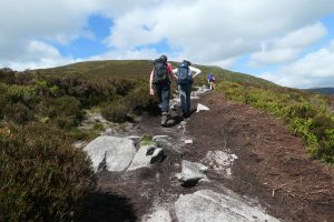
Hill-walkers on the slopes of Cloghernagh using a path suffering from erosion and peat damage.
Renowned for their natural beauty, the Wicklow Uplands understandably attract a great number of visitors, with events of the last couple of years seeing a large increase in people seeking to enjoy the mountains for both physical and mental health reasons.
With its location so close to Ireland’s largest population centre, the Wicklow Mountains National Park and the surrounding uplands, experience higher levels of footfall than other mountain ranges, with impacts spread across many popular routes.
Aside from managed trails such as the Wicklow Way, there is a sizable network of informal paths that criss-cross the uplands, connecting routes, peaks and popular points of interest for hikers and walkers. Evolved through usage over the decades, the impact of this ever-increasing footfall on these paths contributes to the loss of vegetation and soil erosion.
Combined with Ireland’s wet climate and Wicklow’s peat soils, these paths have created scarring to the landscape. With much of the areas affected located within or close to designated Special Areas Of Conservation (SAC), this environmental issue extends to sensitive habitats and its associated biodiversity, that includes rare upland flora.
With noticeable erosion on many of the region’s popular hill-walking routes, it was decided that an extensive survey was required to better inform landowners, both state and private, as to their overall condition. In turn, it was envisaged that the findings would aid decisions on any long-term sustainable management plans and identify any remedial work required to prevent or remedy existing damage.
Mountain Meitheal conducted a survey of selected paths in the Wicklow and Dublin Mountain region in 2002-2003, which provided a valuable baseline to determine both improvement and deterioration of the paths featuring in both assessments. Building on this, an up-to-date path condition survey would provide data to inform any future assessments. It was agreed that the methodology to be used, would be in keeping with the surveying techniques used in other upland areas in an effort to create an easily-understood framework that could be replicated elsewhere or in the future.
Given the scope and scale of the task at hand, a multi-stakeholder approach was certainly required, with Wicklow Uplands Council and Wicklow Mountains National Park (NPWS) leading the project, along with project partners, Coillte, County Wicklow Partnership/Rural Recreation Officer, Wicklow County Council, Mountaineering Ireland, Mountain Meitheal and Dublin Mountains Partnership, who assisted in the planning and delivery throughout.
Collectively, the project partners identified over 160km of upland paths where erosion was evident and set about designing and delivering the project, with funding to conduct the survey successfully obtained through Ireland’s rural development LEADER programme.
 Conducting The Survey
Following a tender process in 2020, ‘Walking the Talk’, a UK based consultancy firm with substantial experience in upland path surveying and management in Scotland and Ireland, was appointed to undertake the survey and author its findings. Led by Chris York, the specialist firm is no stranger to the Irish uplands, with notable work on the Galtee Mountains and the popular peaks of Mount Errigal and Croagh Patrick, as well as several sites in Northern Ireland.
Initially delayed by Covid measures, fieldwork was undertaken in April and July 2021 by Chris York and Marc Vinas, supported by Matt McConway and Vince McAlinden. In keeping with the principles of the project to broaden local expertise on addressing this challenging issue into the future, and to also provide local support and knowledge, the Council’s coordinator Brian Dunne, Ann Fitzpatrick and Wesley Atkinson of NPWS and Mountaineering Ireland’s Access and Conservation Officer, Helen Lawless, accompanied Chris at various times during the survey activities.
The final survey included 50 paths or routes across the Wicklow Mountains, which were divided into a total of 350 sections and amounted to approximately 167km. Using the observations and data collected, the report, now in its final stages of authoring, illustrates the condition of each path and the extent of, or potential for, deterioration that was found to be present.
Perhaps more importantly, it also makes recommendations on the appropriate path repair and restoration techniques that should be considered. These range from’ light touch work’ and early intervention measures through to major repair and realignment, dependent on the level of erosion found, anticipated footfall, gradients and other considerations such as biodiversity or soil type. There are also some paths identified where no repair work is recommended for various reasons such as routes that cross wider, degraded blanket bogs where peatland restoration would be a priority over path management.
A notable and early set of recommendations extracted from the survey, contributed to a successful application being made to the Outdoor Recreation Infrastructure Scheme (ORIS)
by Wicklow County Council, with support from Carol Coad, the Rural Recreation Officer for county Wicklow. A funding allocation of €450,000 was received under Measure 3 of the scheme to undertake extensive remedial stonework on the popular Great Sugar Loaf in north county Wicklow.
The report identifies many challenges in making Wicklow’s upland path network more sustainable, particularly given that much of the network is across peat of a depth of 50cm or more, some of it on steeper slopes where repair options are limited and costly.
One of the most important messages emanating from the report, is the need to build a locally-based team of skilled path workers to tackle the range of issues identified in the survey.
Rather markedly, the report estimates that at least 4,000 days of labour would be required to reduce the impact of recreation on the surveyed paths. An ongoing commitment to maintenance would also be essential. By way of quantifying that estimate, it is the equivalent of a team of 4 working continuously for almost 5 years just to tackle the work outlined in the report.
A recent online public event to share the findings in advance of its publication, saw an audience made up of a varied group of interested parties, participate in the initial discussion around the current challenges and how best to proceed with the information and professional insights gained through the completion of the survey.
Touching on a number of topics, the one that perhaps resonated the most with the online audience, was the project’s invaluable contribution to making informed and wide-reaching decisions to ensure conservation, protection and sustainability remain at the heart of any actions or intervention measures inspired through the Final Report’s publication.
It is envisaged that the comprehensive findings detailed in the report will assist greatly with future funding applications to hopefully commence remedial work soon. The report should also inform future land management in the Wicklow Mountains, as the management of recreational impacts cannot be treated in isolation from other aspects of land management.
The Final Report, Individual Location Reports and a video of the recent online public event titled ‘The Condition Of Upland Paths In The Wicklow Mountains’, are available on our website by clicking HERE.
– Photo of hikers on Cloghernagh appears courtesy of Helen Lawless.
Newsletters Available Online
This newsletter and many of the previous publications are available online to view and download as PDF files directly from the Wicklow Uplands Council website.
CLICK HERE for this issue – Winter 2022.
CLICK HERE to view the full selection of newsletters dating back to 2006.
