
The Sugar Loaf Way
The Sugar Loaf Way
 The ambitious vision to develop and map a series of walks on designated trails that will take visitors and locals from Bray DART / Bus Station to Rathdrum train station is a step closer with the recent development of The Sugar Loaf Way. A series of structured trails that link the towns and villages from Bray to Arklow is the ultimate plan. Taking in Kilmacanogue, Roundwood, Annamoe, Laragh and Rathdrum, the Sugarloaf Way will one day form part of an extensive trail through some of the most beautiful scenery in Ireland.
The Sugar Loaf Way starts at Kilmacanogue at the 1916 Commemorative Garden close to Kilmacanogue village. Crossing the R755 this trail winds its way through charming little country roads and greenways along the foothills of the Great Sugar Loaf Mountain. In times past this was the original coach road from Kilmacanogue to Roundwood.
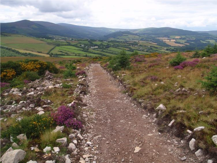
Known locally as the “Car Road” the trail follows a route roughly parallel to the R755 but as it climbs, wonderful views over the Little Sugar Loaf, Bray and Carrigoona open up. Travelling through little narrow lanes bordered with old stone walls, the trail turns south and begins to climb upwards through open-mountain grazing where views over Djouce, Powerscourt, Deerpark and Maulin can be enjoyed. The trail eventually joins the well-used path from the Sugar Loaf car park – a trail head either for staring or completing the Sugar Loaf way.
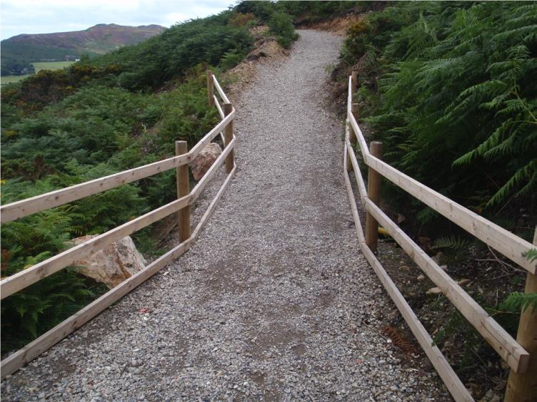
The Way is very well marked with familiar yellow walking man and arrows on a black background. Two gates, and two pedestrian barriers have been erected. A section of new track has been cleared, and gravel laid on one section. Culverts, cross and side drains have been installed and bridges across gullies erected – all in all a major undertaking. There is a large car park at the start/end of the Way at Red Lane and facilities at Kilmacanogue include Pluck’s Bar and two petrol stations with shops. The bus stop in Kilmacanogue is served by three routes.
The well-used track from Red Lane to the Sugar Loaf summit is already very familiar and popular with visitors and local people alike and the Sugar Loaf Way enhances the experience.
 The development of the trail was a huge team effort. Following initial consultations with Wicklow Uplands Council, all of the commonage holders on the Sugar Loaf gave the trail their full support. Funds were secured from Wicklow County Council tourism development and managed by Roundwood & District Community Council. Volunteers from Wicklow Uplands Council project managed the development working closely with Wicklow Rural Partnership and the main contractor. Without the cooperation of these groups the establishment of the trail would not have been possible.
While the trail itself is currently established there are still some improvements in the offing. Map boards for the Way are to be erected at both trailheads. Car parking at the Kilmacanogue end of the trail beside the new 1916 Commemorative Garden is being considered. There are also plans to include a picnic area with seating overlooking Powerscourt and the mountains
The Sugar Loaf Way complies with the National Trails standard and is listed on the National Trails Register. It is a beautiful trail and a welcome addition to the list of Wicklow walks.
Trail Details
Length 4.3k
Climb 206m
Duration 1-2 hours
Trail Head Kilmacanogue village (1916 memorial)
Finishes at Red Lane Carpark (off R755)
Graded Class 4 Strenuous
Further information visitwicklow.ie/wicklow-walks/sugar-loaf-way